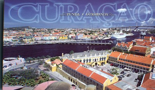
From the back of the card: "Harbour entrance with view of Governor's Palace, Queen Emma Bridge (swinging old lady), and Queen Wilhelmina Bridge."
From a website I found: "Curaçao is one of the five islands of the Netherlands Antilles in the Caribbean. It is located 40 miles off the coast of Venezuela, 42 miles east of Aruba, and 30 miles west of Bonaire. Curaçao is the largest of the five islands and the government of the Netherlands Antilles is located here. The island is about 62 km long and 14 km wide (4 km at its narrowest point in the middle of the island). About 150.000 people live on the island. The local language is Papiamentu (or Papiamento), the official language is Dutch, and English and Spanish are widely spoken. Curaçao is an island with many small and beautiful beaches surrounded by clear and refreshing water." (This text was written by someone who lived on the island ~~ see the rest of the informative text here: www.narin.com/curacao/index.html.)
Sunday, October 03, 2010
Punda, Otrobanda, Curacao
Subscribe to:
Post Comments (Atom)


No comments:
Post a Comment